353 CLEVELAND ROAD,
Huntley, NSW 2530
Development Sites & Land
Price information
Sale
EXPRESSION OF INTEREST end 29th November 2024
Key property information
Land area
Zoning
Private inspections
to arrange a private inspection.
Map of 353 CLEVELAND ROAD
Train stations within 5 km of 353 CLEVELAND ROAD, Huntley, NSW 2530 Distance Dapto Station 4.1 km POWERED BY HERE ©Bus stops within 5 km of 353 CLEVELAND ROAD, Huntley, NSW 2530 Distance Wholahan Av at Bunya St 1.3 km Brooks Reach Rd at Hobbs St 1.5 km Bong Bong Rd Opp McKelly St 1.6 km Morson Av at Brooks Reach Rd 1.7 km Siltstone Av at Morson Av 1.8 km POWERED BY HERE ©
POWERED BY HERE ©
REZONED HOUSING DEVELOPMENT 200+ BLOCKS
To enquire, please email or call 1300 815 0... and enter code 6667
This LAND, probably the last in private ownership in the area, forms part of the Wollongong City Council's Cleveland Road Precinct in the West Dapto Area, and has recently been rezoned for R2, RU2, RE1 housing development.
Part of the 28 hectares, has been rezoned RU2 pending further investigation by Council as to its suitability with cut and fill for additional R2 development. Developers have done extensive cut and fill and managing waterways in similar situations such as at Wilton Greens, and South West Sydney, maximising returns.
The land consists of two adjoining titles, both with Cleveland Road frontage, House block Lot1 DP1126171 and Grazing block Lot1 DP 741423.
Photographs show the general development areas and some aspects of the 70 square Ranch House, sheds, improvements and grazing activities.
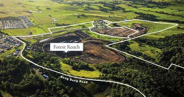
The land is on Cleveland Road, opposite the well advanced development "Forest Reach" by Stockland, where many houses are already constructed.
We would expect some 200 - 240 blocks to be developed on this land depending on strategic planning.
The information below has been extracted from the WCC public viewable web site, for summary details relevant to the imminent development of the land.
For further information please follow the link to Councils Neighbourhood Plan (Eastern Zone) where the Western Zone is viewable. (Plan work in progress).
LINK: https://wollongong.nsw.gov.au/__data/assets/pdf_file/0025/243808/Item-2-Public-Exhibition-Draft-Neighbourhood-Plan-Cleveland-Road-East-Precinct,-Cleveland-Road,-Cleveland.pdf
Note: Persons submitting an EOI or other offer should satisfy themselves as to the development possibilities of this land.
___________________________________________________________________________________________________
• Wollongong Local Strategic Planning Statement (LSPS) 2020. The site is recognised as being within the urban release area and is covered by the West Dapto Vision (discussed below). The LSPS recognises that the West Dapto urban release area is intended to be a significant source of housing supply and will also provide for protection of environmental assets. The LSPS also recognises that transport, infrastructure and services – including community and recreational facilities.
• Council’s West Dapto Vision (2018). The site is part of the West Dapto urban release area and is recognised as a major regional urban release area. The Vision estimates that the urban release area would potentially provide 19,500 dwellings (and a population of over 56,000 people). The Vision seeks to concentrate higher densities around centres and public transport nodes and collocate compatible land uses to reduce reliance on private vehicles. The Vision indicates that the precinct is intended to have a village centre, 2-5ha neighbourhood park and is located next to an identified district park. The Vision also recognises that community facilities, schools and childcare are an important component of a strong, healthy and well-connected community.
• Council’s Housing Strategy (2023) which identifies West Dapto as a key housing supply area.
The subject site is identified as flood prone land, being located within the Mullet Creek catchment. Mullet Creek is to the south, and a tributary of Mullet Creek to the north. Several smaller drainage lines feed into the two larger creeks. Flood impacts have a significant influence on the development patterns within the precinct. The draft Planning Proposal for Cleveland Road proposes a cut/fill solution to the flood impacts that require the cooperation of adjoining landowners/developers for the proposed development areas to be realised
Planning Proposal Site The Cleveland Road Planning Proposal covers the eastern portion of Stage 3 of the WDURA along Cleveland Rd, Cleveland (Attachments 1 and 2). The site is bound by Dapto High School to the east, Horsley to the north, the Stockland Stage 3 development to the west, and Mullet Creek to the south. The site consists of 21 individual lots (table 1) and has a site area of 382 hectares (including roads and creeks). Phase 1 of the Planning Proposal rezoned most of the land holding.
The balance of the precinct referred to as the deferred area, is still zoned RU2 Rural Landscapes. Phase 2 is proposed to rezone the phase 1 lands as well as the additional deferred lands, to avoid any zoning gaps.
EXPRESSION OF INTEREST
The offers should be submitted to arrive no later than 5:00 PM on Friday 29th November 2024
Please submit your EOI in writing by email.
Please phone or text enquiries to the owners to obtain additional information, or to arrange an on site inspection by appointment.
Most of the property can be seen from the 750m frontage on Cleveland Road.
After close of the EOI period, the offers received will be assessed in detail, and further discussions will follow directly with the principals.
A significant or attractive offer may result in a sale prior to closure on 29/11/2024.
To enquire, please email or call 1300 815 0... and enter code 6667
This LAND, probably the last in private ownership in the area, forms part of the Wollongong City Council's Cleveland Road Precinct in the West Dapto Area, and has recently been rezoned for R2, RU2, RE1 housing development.
Part of the 28 hectares, has been rezoned RU2 pending further investigation by Council as to its suitability with cut and fill for additional R2 development. Developers have done extensive cut and fill and managing waterways in similar situations such as at Wilton Greens, and South West Sydney, maximising returns.
The land consists of two adjoining titles, both with Cleveland Road frontage, House block Lot1 DP1126171 and Grazing block Lot1 DP 741423.
Photographs show the general development areas and some aspects of the 70 square Ranch House, sheds, improvements and grazing activities.
The land is on Cleveland Road, opposite the well advanced development "Forest Reach" by Stockland, where many houses are already constructed.
We would expect some 200 - 240 blocks to be developed on this land depending on strategic planning.
The information below has been extracted from the WCC public viewable web site, for summary details relevant to the imminent development of the land.
For further information please follow the link to Councils Neighbourhood Plan (Eastern Zone) where the Western Zone is viewable. (Plan work in progress).
LINK: https://wollongong.nsw.gov.au/__data/assets/pdf_file/0025/243808/Item-2-Public-Exhibition-Draft-Neighbourhood-Plan-Cleveland-Road-East-Precinct,-Cleveland-Road,-Cleveland.pdf
Note: Persons submitting an EOI or other offer should satisfy themselves as to the development possibilities of this land.
___________________________________________________________________________________________________
• Wollongong Local Strategic Planning Statement (LSPS) 2020. The site is recognised as being within the urban release area and is covered by the West Dapto Vision (discussed below). The LSPS recognises that the West Dapto urban release area is intended to be a significant source of housing supply and will also provide for protection of environmental assets. The LSPS also recognises that transport, infrastructure and services – including community and recreational facilities.
• Council’s West Dapto Vision (2018). The site is part of the West Dapto urban release area and is recognised as a major regional urban release area. The Vision estimates that the urban release area would potentially provide 19,500 dwellings (and a population of over 56,000 people). The Vision seeks to concentrate higher densities around centres and public transport nodes and collocate compatible land uses to reduce reliance on private vehicles. The Vision indicates that the precinct is intended to have a village centre, 2-5ha neighbourhood park and is located next to an identified district park. The Vision also recognises that community facilities, schools and childcare are an important component of a strong, healthy and well-connected community.
• Council’s Housing Strategy (2023) which identifies West Dapto as a key housing supply area.
The subject site is identified as flood prone land, being located within the Mullet Creek catchment. Mullet Creek is to the south, and a tributary of Mullet Creek to the north. Several smaller drainage lines feed into the two larger creeks. Flood impacts have a significant influence on the development patterns within the precinct. The draft Planning Proposal for Cleveland Road proposes a cut/fill solution to the flood impacts that require the cooperation of adjoining landowners/developers for the proposed development areas to be realised
Planning Proposal Site The Cleveland Road Planning Proposal covers the eastern portion of Stage 3 of the WDURA along Cleveland Rd, Cleveland (Attachments 1 and 2). The site is bound by Dapto High School to the east, Horsley to the north, the Stockland Stage 3 development to the west, and Mullet Creek to the south. The site consists of 21 individual lots (table 1) and has a site area of 382 hectares (including roads and creeks). Phase 1 of the Planning Proposal rezoned most of the land holding.
The balance of the precinct referred to as the deferred area, is still zoned RU2 Rural Landscapes. Phase 2 is proposed to rezone the phase 1 lands as well as the additional deferred lands, to avoid any zoning gaps.
EXPRESSION OF INTEREST
The offers should be submitted to arrive no later than 5:00 PM on Friday 29th November 2024
Please submit your EOI in writing by email.
Please phone or text enquiries to the owners to obtain additional information, or to arrange an on site inspection by appointment.
Most of the property can be seen from the 750m frontage on Cleveland Road.
After close of the EOI period, the offers received will be assessed in detail, and further discussions will follow directly with the principals.
A significant or attractive offer may result in a sale prior to closure on 29/11/2024.
To enquire, please email or call 1300 815 0... and enter code 6667
Property ID: 504712912Last Updated: 25 Oct 2024
13008150...
353 CLEVELAND ROAD
Huntley, NSW 2530

Property Now - BRISBANE CITYSuite 3129, 29/97 Creek Street
BRISBANE CITY, QLD 4000
BRISBANE CITY, QLD 4000
Similar properties
Other properties you might be interested in based on the location and property type you are looking at.


Price Guide | Offers above $8,000,000 + GST
11, 14, 18 & 22 Macquarie Place,Haywards Bay, NSW 2530 1.5 ha (3.72 acres)Development Sites & Land

Contact Agent
Lot 22 Canterbury Road,Kembla Grange, NSW 2526 900 m²Warehouse, Factory & Industrial • Development Sites & Land